Delta Levees Investment Strategy

About Delta Levees
Flood risk is one of the most pressing threats to the Sacramento-San Joaquin Delta and will continue to worsen in the future with changes in sea levels, precipitation, hydrology, and temperatures. The Delta Levees Investment Strategy (DLIS) is a risk-based prioritization for levee investments in the Delta that became California state law as part of the Delta Plan on January 1, 2024. (View the associated regulations in PDF format.) The goal is to maximize flood protection for people, property, water supply, the Delta ecosystem, and infrastructure, benefiting all Californians.
Scroll through our interactive storymap to learn more about the importance of DLIS and how it was developed.
The Delta’s 1,100 miles of levees provide 24/7 protection for residences, agricultural lands, and infrastructure, which need deliberate and sustainable maintenance and funding to ensure they can perform the important work they do. Many of the levees date back to when the Delta was reclaimed for agricultural purposes in the late 1800s. Many have been maintained and improved, but more work remains, which can only be completed by working together.
How does the DLIS work?
- The DLIS assigns a risk-based priority of very-high, high, or other to each island or tract located within the legal boundaries of the Sacramento-San Joaquin Delta and Suisun Marsh (Delta).
- The California Department of Water Resources (DWR) should fund levee projects at very-high priority islands or tracts before approving projects at high priority or other priority islands or tracts.
- The DLIS provides that if available funds are sufficient to fully fund levee improvements at the very-high priority islands or tracts, then funds for levee improvements on high-priority islands or tracts may be provided, and after those projects have been fully funded, then projects at other priority islands or tracts may be funded.
What does the DLIS require?
- The DLIS regulation directs DWR to invest public resources first in Delta levees with the greatest potential to protect people, property, and State interests, before investing public resources in Delta levees with lower potential to achieve these objectives.
- Additionally, the regulation requires DWR to submit a written report to the Council annually at least 45 days before a presentation to the Council and no later than March 1 of each calendar year.
- The report must include certain information that describes DWR’s decisions to award State funds for Delta levee improvement projects.
- When DWR’s contributions toward such projects vary from the DLIS priorities, the annual report is required to identify how the funding is inconsistent with the priorities, describe why variation from the DLIS priorities is necessary, and explain how the funding nevertheless protects lives, property, and State interests.
How levees are currently prioritized as of January 1, 2024
| Priority | Locations |
|---|---|
| Very High Priority | Bacon Island, Bethel Island, Bishop/DLIS-14 (North Stockton), Brannan-Andrus, Byron Tract, DLIS-19 (Grizzly Slough Area), DLIS-28, DLIS-33, DLIS-63 (Grizzly Island Area), Drexler Tract, Dutch Slough, Hasting Tract, Hotchkiss Tract, Jersey Island, Jones Tract (Upper and Lower), Maintenance Area 9 North, Maintenance Area 9 South, McCormack-Williamson Tract, McDonald Island, McMullin Ranch, Middle and Upper Roberts Island, New Hope Tract, North Stockton, Paradise Junction, Reclamation District 17, Ryer Island, Sherman Island, Staten Island, Terminous Tract, Twitchell Island, Upper Andrus Island, Victoria Island, Webb Tract |
| High Priority | Bouldin Island, Brack Tract, Bradford Island, Cache Haas Area, Central Stockton, Clifton Court Forebay, DLIS-01 (Pittsburg Area), DLIS-07 (Knightsen Area), DLIS-08 (Discovery Bay Area), DLIS-20 (Yolo Bypass), DLIS-22 (Rio Vista), DLIS-26 (Morrow Island), DLIS-29, DLIS-30, DLIS-31 (Garabaldi Unit), DLIS-32, DLIS-39, DLIS-41 (Joice Island Area), DLIS-44 (Hill Slough Unit), DLIS-55, DLIS-59, Egbert Tract, Fabian Tract, Glanville, Grand Island, Holland Tract, Honker Bay, Kasson District, Libby McNeil, Little Egbert Tract, Lower Roberts Island, Mandeville Island, Mossdale Island, Netherlands, Palm-Orwood, Paradise Cut, Pearson District, Pescadero District, Rindge Tract, River Junction, Shima Tract, Stewart Tract, Sunrise Club, Tyler Island, Union Island East, Veale Tract, Walnut Grove, Woodward Island, Yolano |
| Other Priority | Atlas Tract, Bixler Tract, Canal Ranch Tract, Chipps Island, Coney Island, Dead Horse Island, DLIS- 06 (Oakley Area), DLIS-10, DLIS-15, DLIS-17, DLIS-18, DLIS-25, DLIS-27, DLIS-34, DLIS-35, DLIS-36, DLIS-37 (Chadbourne Area), DLIS-40, DLIS-43 (Potrero Hills Area), DLIS-46, DLIS-47, DLIS-48, DLIS-49, DLIS-50, DLIS-51, DLIS-52, DLIS-53, DLIS- 54, DLIS- 56, DLIS- 57, DLIS- 62, Drexler Pocket, Ehrheardt Club, Empire Tract, Fay Island, Glide District, Holt Station, Honker Lake Tract, King Island, Lisbon District, Medford Island, Mein's Landing, Merritt Island, Peters Pocket, Pico- Naglee, Prospect Island, Quimby Island, Randall Island, Rio Blanco Tract, Rough And Ready Island, Shin Kee Tract, Stark Tract, Sutter Island, Venice Island, Walthall, West Sacramento, Wetherbee Lake, Winter Island, Wright-Elmwood Tract |
Island and tract names in the table above beginning with “DLIS” indicate that a particular unit of analysis previously had no island or tract name (or associated RD), or that the tract was especially delineated for this effort. Maps to their location can be found below.
The Delta Levees Investment Strategy Decision Support Tool was developed to assist the Council in the development of a transparent strategy for prioritizing State-funded levee investments in the Delta. The tool uses an analytical framework to evaluate flood risk to each Delta tract or island. It enables the Council and stakeholders to explore flood risk results for each island across different time frames and future scenarios; and assists the Council in developing the prioritized list of islands for levee investment.
- March 2024 (covering FY 2023-24)
- View the March 2024 Delta Stewardship Council’s analysis in PDF format.
- December 2023 (covering FY 2019-23)
- View the December 2023 Delta Stewardship Council’s analysis in PDF format.
- November 2019
- View the November 2019 Delta Stewardship Council’s analysis in PDF format.
View associated maps in Appendix P of the DLIS regulations PDF document.

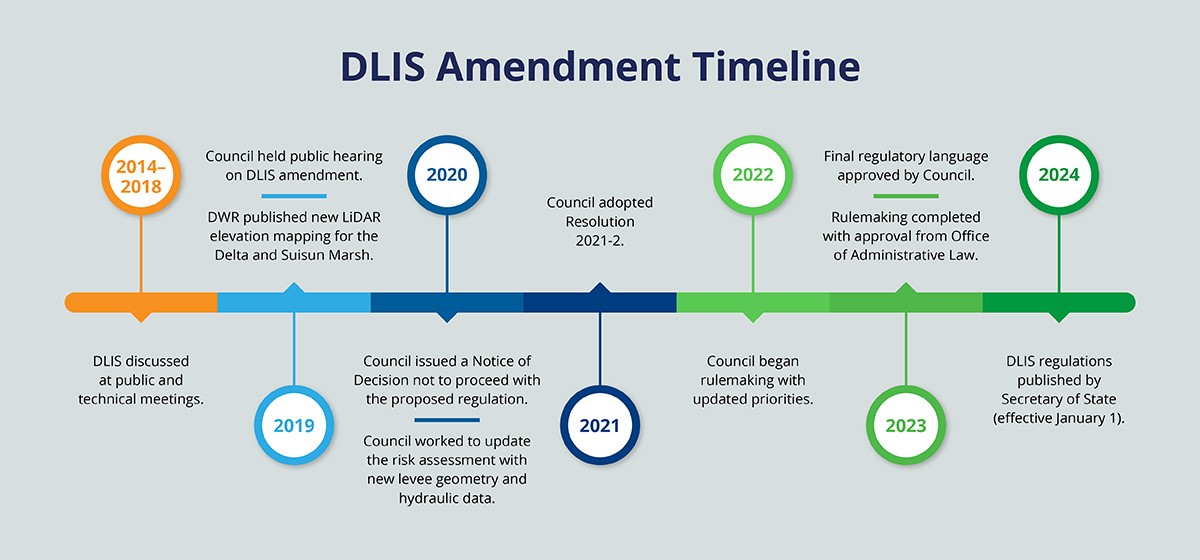
Between 2014 and 2018, the DLIS was discussed at 40 meetings with technical experts, 27 Council meetings, and 4 public workshops. In April 2018, the DLIS was included in Delta Plan amendments that were adopted by the Council. In 2019, the Council initiated a rulemaking process to adopt the DLIS and the Delta Plan amendments into regulation. The Council held a public comment period from July 5, 2019, to August 19, 2019, and convened a public hearing during the Council’s public meeting on August 22, 2019.
Also, in 2019, the California Department of Water Resources (DWR) published new Light Detection and Ranging (or LiDAR) elevation imaging of the Delta and Suisun Marsh for 2017. The LiDAR imaging provided updated information about the height of levees and island floors. To allow for more time to evaluate the LiDAR information to determine whether the priorities identified in the DLIS, the 2018 Delta Plan amendments, and the proposed regulation needed to be modified because of changed levee or island conditions, the Council issued a Notice of Decision Not to Proceed with the proposed regulation on March 26, 2020. The Council also amended the Delta Plan to restore the version of Delta Plan Policy RR P1 adopted in 2013.
Beginning in 2020, the Council worked to update the risk assessment with new levee geometry and hydraulic data. The initial results were presented to the Council at its May 2021 meeting. Additional refinements were made to the prioritization to account for socially vulnerable populations. The adjusted results were brought to the Council at its August 2021 meeting. The Council adopted Resolution 2021-2 (Resolution) which adopted revisions to the policy set forth in Section 5012, approved the addendum to the Environmental Impact Report for the Delta Plan Amendments, and directed the initiation of this rulemaking process to amend Section 5012 and Section 5001.
In 2022, the Council began rulemaking with updated priorities. This update would assign a priority of very-high, high, or other to each island or tract located within the legal boundaries of the Delta and Suisun Marsh.
Additionally, under the proposed amendment, the DWR would fund levee improvement projects at very-high priority islands or tracts before funding levee improvement projects at high or other priority islands or tracts. If available funds are sufficient to fully fund levee improvements at the very-high priority islands or tracts, then levee improvements on high priority islands or tracts may be provided, and after those projects have been fully funded, then levee improvement projects at other priority islands or tracts may be funded.
The proposed amendment would also require the DWR to submit an annual report to the Council including information describing Delta levee investments relative to the priorities.
In 2023, the Council approved the regulatory language at the February Council meeting and submitted the rulemaking package to the Office of Administrative Law (OAL). After review, OAL requested a change to the regulatory language and the Council issued an additional 15-day comment period in July on those changes. The Council received OAL approval of the updated regulation in September 2023.
In 2024, the Delta Levees Strategy regulations went into effect on January 1, when they were published by the Office of Administrative Law.
For more information, view the Administrative Procedure Act Rulemaking Process PDF.

